Modelo para la determinación del volumen de aplicación de fitosanitarios en cultivos de tomate en invernadero

Fecha de defensa:

2013

Doctorando:

Francisco César Páez Cano

Directores:

Julián Sánchez-Hermosilla López

Fernando Carvajal Ramírez

Francisco Agüera Vega

https://www.educacion.gob.es/teseo/mostrarRef.do?ref=1045077

RESUMEN

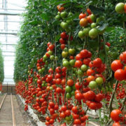
La aplicación de productos fitosanitarios para el control de plagas y enfermedades en invernadero, se realiza habitualmente mediante el empleo de equipos poco tecnificados, como son las pistolas pulverizadoras manuales. Se trata de equipos de bajo coste, fácil mantenimiento y adecuados para controlar problemas fitosanitarios puntuales y localizados. Sin embargo, presentan una serie de inconvenientes como son: falta de uniformidad, elevadas pérdidas en el suelo, alto riesgo de exposición del operador y dificultad para regular la presión y los volúmenes de aplicación.

Además, en las etiquetas de los envases de productos fitosanitarios, aparece la concentración o el volumen de caldo a aplicar por unidad de superficie en función del tipo de cultivo. En invernadero, los cultivos tienen un crecimiento rápido, por lo que, una tasa de aplicación basada en una cantidad fija de producto por unidad de superficie puede dar como resultado grandes pérdidas y/o sobredosis de producto en los primeros estadíos de crecimiento, o tasas insuficientes cuando el cultivo esté completamente desarrollado. Por tanto, para resolver estos problemas, el volumen de aplicación debe estar adaptado a la masa vegetal presente en el invernadero cuando se realice el tratamiento.

En este trabajo de tesis se han desarrollado 9 modelos, para un cultivo de tomate de invernadero, que permiten estimar la superficie foliar (LAI) a partir de parámetros geométricos fácilmente medibles en la masa vegetal. El modelo basado en el PRV (Plant Row Volume) es el que ha dado mejores resultados. Para el cálculo del volumen de aplicación, se ha adaptado al índice PRV el modelo de dosificación basado en la Deposición Media, que ha sido validado desde un punto de vista técnico y biológico. El uso de este modelo ha permitido una reducción de más del 30% de la cantidad de fitosanitario aplicado, sin pérdida de rendimiento. El PRV permite el uso de estrategias de aplicación adaptadas al cultivo, con un gran ahorro en las cantidades de producto químico utilizado, en comparación con el sistema convencional de dosificación.

Además se ha desarrollado una aplicación informática, denominada GreenRate, cuyo objetivo es facilitar el uso del modelo de dosificación basado en la Deposición Media adaptado al PRV, permitiendo así el cálculo del volumen de aplicación y de los parámetros operacionales necesarios durante el tratamiento. También se han elaborado una serie de tablas y gráficos que facilitan el uso del modelo de estimación del volumen de aplicación

Arqueología Industrial: Estudio de la Torre del Humo de la Fábrica de San Andrés (Adra, Almería). Documentación geométrica, reconstrucción virtual e integración urbanística

Fecha de defensa:

2013

Doctorando:

Eva María Quintana Delgado

Directores:

Fernando Carvajal Ramírez

Francisco Agüera Vega

Julián Sánchez-Hermosilla López

https://www.educacion.gob.es/teseo/mostrarRef.do?ref=1042947

RESUMEN

Actualmente, Almería se abre camino dando la espalda a un recurso económico que constituyó el principal soporte material de la provincia durante más de un siglo; la minería (Pérez de Perceval, 1989; Sánchez, 1992). De aquella época, sólo quedan las ruinas de las minas, fábricas, embarcaderos… que, en distintas zonas de la provincia, son mudo testimonio de un pasado no lejano.
Este legado del siglo XIX está muy presente en Adra, con los restos de la Fábrica de San Andrés, una de las principales fundiciones de plomo de la época gracias a su localización y avances tecnológicos (López, 2008; Sánchez, 2006).

La base en la que se sustenta la elaboración y ejecución de la presente tesis, es el estudio integral de esta Fundición, que se estructurará en tres partes: la primera consistirá en conocer el funcionamiento de la Fábrica en su época de esplendor y analizar los acontecimientos que así lo permitieron, en una segunda parte se analizará el presente de la Fábrica para conocer su uso actual, su integración en la ciudad, etc. y por último se procederá a realizar una actuación de futuro consecuente con los resultados obtenidos.
Para contextualizar históricamente la Fábrica de San Andrés, en primer lugar, se analizará su relación con la Sierra de Gádor ya que gracias a ella Almería vivió este proceso industrial, de cuya importancia se ha escrito gran cantidad de información (Cara, 2002; Muñoz. y Sánchez, 1991; Nadal, 1975; Pérez de Perceval y Sánchez, 2001; Pérez de Perceval, 1984). Además la fábrica abderitana es comparada con otras para atestiguar su importancia en la época y explicar detalladamente su funcionamiento y componentes. Dentro de esta sección se realiza un estudio gráfico de todos sus componentes.
También hay que caracterizar el estado actual de la fundición y los elementos de ésta que han llegado a nuestros días. Estos elementos son, las Torres de los Perdigones, la Fabriquilla del Vinagre, la Torre del Humo y la cámara de condensación, pero no todos en igualdad de condiciones, debido a que las dos primeras se convierte en objetivos de numerosas restauraciones y emblema de la ciudad, mientras que las otras dos se encuentran en un estado de tal deterioro que hace peligrar su existencia. Deben analizarse las causas del aparente abandono de algunos de sus componentes y hacerse una propuesta de restauración, en su caso.
Con todo esto se dará a estos elementos, y especialmente a la Torre del Humo, el reconocimiento que probablemente merezca, a través de la propuesta de rehabilitación e integración en la ciudad, ayudándonos con los medios gráficos actuales.

Análisis y evaluación de riesgos de incidencias naturales en el sistema productivo agrario intensivo de Almería

Fecha de defensa:

2011

Doctorando:

Carlos Fernández Sierra

Directores:

Fernando Carvajal Ramírez

Francisco Agüera Vega

Jerónimo José Pérez Parra

https://www.educacion.gob.es/teseo/mostrarRef.do?ref=1039563

RESUMEN

La estructura del invernadero es el elemento cualitativamente más importante de la explotación superintensiva predominante en la provincia de Almería, y del que depende en gran medida la capacidad productiva de la misma. A su vez, es el elemento que libera la producción agrícola del azar meteorológico.

Desde el punto de vista económico, la inversión que representa la construcción o mejora de un invernadero, es elevada. Por este motivo, asegurar las estructuras de los invernaderos se antoja como una auténtica necesidad a la hora de garantizar al agricultor su medio de vida.

La Tesis Doctoral se circunscribe dentro del área de estudios para desarrollar las nuevas coberturas previstas tras la modificación de la Ley de seguros agrarios relativas a daños sobre instalaciones y medios elementos productivos de la parcela.

Se estudia el escenario actual de los seguros agrarios, y en particular la situación actual del seguro de estructuras de invernaderos. Posteriormente se analizan los daños, según estudios anteriores de siniestralidad, de las causas que producen estos daños. Se hace un estudio estructural de los elementos que componen el invernadero, efectos cualitativos y magnitud de dichos daños. A raíz de estos datos, se elabora un modelo basado en un sistema de  scoring, base de datos alimentada por visitas técnicas de campo a distintas explotaciones. De esta manera, se realiza una selección de riesgos teniendo en cuenta diferentes variables técnicas que nos capacita a la hora de discernir entre la asegurabilidad o no de distintas estructuras de invernadero. Por último, se caracteriza el parque de invernaderos de la provincia de Almería en relación a la asegurabilidad de los mismos

Measuring sunflower nitrogen status from an unmanned aerial vehicle-based system and an on the ground device

Francisco Agüera Vega, Fernando Carvajal Ramírez, Mónica Pérez Saiz 2011 UAV-g 2011. International Archives of the Photogrammetry, Remote Sensing and Spatial Information Sciences – ISPRS Archives 38: 201-206 http://www.scopus.com/inward/record.url?eid=2-s2.0-84924042320&partnerID=MN8TOARS ABSTRACT Precision agriculture recognizes the inherent spatial variability associated with soil characteristics, land morphology and crop growth, and uses this information to prescribe the most appropriate […]

Surveying a landslide in a road embankment using unmanned aerial vehicle Photogrammetry

Fernando Carvajal Ramírez, Francisco Agüera Vega, Mónica Pérez Saiz

2011

UAV-g 2011. International Archives of the Photogrammetry, Remote Sensing and Spatial Information Sciences – ISPRS Archives 38: 201-206

http://www.scopus.com/inward/record.url?eid=2-s2.0-84924056936&partnerID=MN8TOARS

ABSTRACT

Most of the works of civil engineering, and some others applications, need to be designed using a basic cartography with a suitable scale to the accuracy and extension of the plot. The Unmanned Aerial Vehicle (UAV) Photogrammetry covers the gap between classical manned aerial photogrammetry and hand-made surveying techniques because it works in the close-range domain, combining aerial and terrestrial photogrammetry, but also introduces low-cost alternatives. The aim of this work is developing of an accurate and low-cost method to characterize landslides located on the size of a road. It was applied at the kilometric point 339 belonging to the A92 dual carriageway, in the Abla municipal term, province of Almeria, Spain. A photogrammetric project was carried out from a set of images taken from an md4-200 Microdrones with an on-board calibrated camera 12 Megapixels Pentax Optio A40. The flight was previously planned to cover the whole extension of the embankment with three passes composed of 18 photos each one. All the images were taken with the vertical axe and it was registered 85% and 60% longitudinal and transversal overlaps respectively. The accuracy of the products, with planimetric and altimetric errors of 0.049 and 0.108m repectively, lets to take measurements of the landslide and projecting preventive and palliative actuations.

Digital camera calibration using images taken from an unmanned aerial vehicle

Mónica Pérez Saiz, Francisco Agüera Vega, Fernando Carvajal Ramírez

2011

UAV-g 2011. International Archives of the Photogrammetry, Remote Sensing and Spatial Information Sciences – ISPRS Archives 38: 167-171

http://www.scopus.com/inward/record.url?eid=2-s2.0-84924067582&partnerID=MN8TOARS

ABSTRACT

For calibrating the camera, an accurate determination of the interior orientation parameters is needed. For more accurate results, the calibration images should be taken under conditions that are similar to the field samples. The aim of this work is the establishment of an efficient and accurate digital camera calibration method to be used in particular working conditions, as it can be found with our UAV (Unmanned Aerial Vehicle) photogrammetric projects. The UAV used in this work was md4-200 modelled by Microdrones. The microdrone is also equipped with a standard digital non-metric camera, the Pentax Optio A40 camera. To find out the interior orientation parameters of the digital camera, two calibration methods were done. A lab calibration based on a flat pattern and a field calibration were fulfilled. To carry out the calibration, Photomodeler Scanner software was used in both cases. The lab calibration process was completely automatic using a calibration grid. The focal length was fixed at widest angle and the network included a total of twelve images with ± 90° roll angles. In order to develop the field calibration, a flight plan was programmed including a total of twelve images. In the same way as in the lab calibration, the focal length was fixed at widest angle. The field test used in the study was a flat surface located on the University of Almería campus and a set of 67 target points were placed. The calibration field area was 25 x 25 m approximately and the altitude flight over ground was 50 m. After the software processing, the camera calibration parameter values were obtained. The paper presents the process, the results and the accuracy of these calibration methods. The field calibration method reduced the final total error obtained in the previous lab calibration. Furthermore the overall RMSs obtained from both methods are similar. Therefore we will apply the field calibration results to all our photogrammetric projects in which the flight high will be close to 50 m.

Relationship between atmospheric corrections and training-site strategy with respect to accuracy of greenhouse detection process from very high resolution imagery

Fernando Carvajal Ramírez, Francisco Agüera, Fernando J. Aguilar, Manuel A. Aguilar

2010

International Journal of Remote Sensing, 31: 2977 — 2994

http://dx.doi.org/10.1080/01431160902946580

ABSTRACT

Frequently, satellite images that are acquired to extract a target surface are atmospherically corrected prior to the detection process. Thus, the unification of measure units is achieved, and atmospheric effects are removed from various imagery sources or taken at different dates. In this paper, four increasing levels of atmospheric corrections are applied (Top-Of-Atmosphere transformation: TOA; Apparent Reflectance Model: ARM; Flat Areas Model: FAM; Non-Flat Areas Model: NFAM). Then, the classification process is carried out using two strategies of training-site definitions (statistically purified and crude training sites) and two satellite imagery sources (QuickBird and Ikonos). Three-way Analysis of Variance (ANOVA) tests and Fisher’s least-significant difference tests are included in quality classification assessment, based on four accuracy indexes. Two images from both remote sensors are orthorectified, and then it is checked that all selected atmospheric correction levels have significantly different influences on the statistics of both orthoimages. Taking into account the conditions established in this work, it is concluded that a lower atmospheric correction level would be preferred because it does not present significantly worse results than other levels considered. Training sites would not be statistically purified, and QuickBird or Ikonos would be chosen, depending on the aspect of the greenhouse detection accuracy preferred.

Geometric accuracy assessment of the orthorectification process from very high resolution satellite imagery for Common Agricultural Policy purposes

Manuel A. Aguilar, Francisco Agüera Vega, Fernando J. Aguilar, Fernando Carvajal Ramírez

2008

International Journal of Remote Sensing 29: 7181-7197

http://dx.doi.org/10.1080/01431160802238393

ABSTRACT

This study has, as its main aim, the assessment of different sensor models to achieve the best geometric accuracy in orthorectified imagery products obtained from IKONOS Geo Ortho Kit and QuickBird basic imagery. The final orthoimages are compared, both geometrically and visually, with the panchromatic orthophotos based on a photogrammetric flight with an approximate scale of 1 : 20 000, which are now used for the European Union Common Agricultural Policy in Andalusia (Spain). Two‐dimensional root mean square (RMS2d) errors in independent check points are used as accuracy indicators. The ancillary data were generated by high accuracy methods: (1) check and ground control points (GCPs) were measured with a differential global positioning system and (2) an accurate digital elevation model was used for image orthorectification. Two sensor models were used to correct the satellite data: (1) a three‐dimensional (3D) rational function refined by the user with zero‐ (RPC0) or first‐(RPC1) order polynomial adjustment and (2) the 3D Toutin physical model (CCRS). For the IKONOS image, the best results in the final orthoimages (RMS2d of about 1.15 m) were obtained when the RPC0 model was used. Neither a large number of GCPs (more than nine), nor a better distribution of them, improved the results obtained with the RPC0. For the QuickBird image, the CCRS model generated the best results (RMS2d of about 1.04 m), although it was sensitive to the number and distribution of the GCPs used in its computation.

Developing digital cartography in rural planning applications

Fernando J. Aguilar, Fernando Carvajal Ramírez, Manuel A. Aguilar, Francisco Agüera Vega

2007

Computers and Electronics in Agriculture 55 : 89–106

http://dx.doi.org/10.1016/j.compag.2006.12.008

ABSTRACT

The main objective of the present study is to develop an efficient methodology at a reasonable cost, that will allow the use of the latest technological developments in the areas of image analysis and geographical information systems (GIS) for the generation, compilation, operation and updating of digital cartography on a large scale in rural environments. The various possibilities offered by the current analytic cartography allow the utilization of this spatially geo-referenced database to obtain quantitative and qualitative information of great interest for the study of planning, land organization and sustainable rural development.

The methodological proposal to achieve this objective consists of three well differentiated phases: the generation of digital cartography from 1:5000 scale colour aerial photographs, the compilation of cartographic information obtained in an open architecture GIS, and, finally, the periodical updating of the GIS cartographic database by means of digital treatment and geometrical modelling of high resolution satellite imagery.

The methodology described above is being developed and applied in a specially interesting rural milieu, like “El Campo de Níjar”, located in the province of Almería (Spain) on the border with the nature reserve “Parque Natural de Cabo de Gata”.

Minimising the Earthwork Cost in the Construction of Irrigation Offstream Reservoirs

Francisco Agüera Vega, Fernando J. Aguilar, Manuel A. Aguilar, Fernando Carvajal Ramírez

2007

Water Resources Management 21: 375–397

http://dx.doi.org/10.1007/s11269-006-9021-7

ABSTRACT

In the majority of agricultural areas it is necessary to construct irrigation offstream reservoirs to store the required amount of water to be available at any time. In this type of projects, the earthwork can represent up to 80% of the total budget, therefore, one of the criteria in their design is minimising this cost. Due to the fact that the minimising process is carried out by the trial and error method, calculating the cost in different locations and devoting a great deal of time and effort to these calculations, finding the definite location for the lowest earthwork cost is very complicated and difficult to achieve. In this study a computer application which carries out this process is presented. Once the geometry of the offstream reservoir has been defined, as well as that of the land where it will be located and the cut and fill surfaces slopes, a boundary can be fixed within which it will be constructed, and the computer application will perform automatically the calculation of the cost of the earthwork in a series of locations. The different locations within the defined limit are obtained by moving the offstream reservoir along West-East and South-North directions, changing the crown elevation, and even making it rotate with regard to a vertical axis. The range of values for these movements and the increase in variation as they go from one to the next will determine the number of places where the cost of the earthwork will be calculated. The cost function incorporated to the programme allows to take into account the types of materials that will be excavated and the disposition of the soil layers. In the first place, a series of algorithms are detailed which have been developed to do the calculations, then the computer application is described which integrates these algorithms, and finally an application of the programme is explained in which the minimum cost is sought for an offstream reservoir with a capacity of 100000 m3.