Assessment of photogrammetric mapping accuracy based on variation ground control points number using unmanned aerial vehicle

Francisco Agüera Vega, Fernando Carvajal Ramírez, Patricio J. Martínez Carricondo

2017

Measurement 98: 221-227

http://dx.doi.org/10.1016/j.measurement.2016.12.002

ABSTRACT

Digital Surface Models and orthoimages at high spatial and temporal resolution and accuracy is of increasing importance for many applications. From several years ago photogrammetry-UAV is being used to produce these topographic products. The aim of this study is to analyse the influence of the number of Ground Control Points used for georeferencing on Digital Surface Model and orthoimage accuracies obtained with UAV-photogrammetry. In this purpose, 160 images were taken on a 17.64 ha surface at 120 m altitude above ground level, and five replications of photogrammetric projects taking into account 4, 5, 6, 7, 8, 9, 10, 15, and 20 GCPs were made. Root Mean Square Error (RMSE) was used as accuracy measurement.
Optimal results for RMSEX, RMSEY and RMSEXY mean ± standard deviation values were reached for 15 GCPs: 3.3 ± 0.346, 3.2 ± 0.441, 4.6 ± 0.340 and 4.5 ± 0.169 cm respectively. Similar conclusions was derived for vertical accuracy: lower RMSEZ mean ± standard deviation values were reached for 15 and 20 GCPs: 5.8 ± 1.21 cm and 4.7 ± 0.860 cm respectively.
In view of these results maps at 1:150 scale and contour interval of 15 cm can be obtained from
UAV-photogrammetry.

Téncicas fotogramétricas desde vehículos aéreos no tripulados aplicadas a la obtención de productos cartográficos para la Ingeniería Civil

Fecha de defensa:

2016

Doctorando:

Patricio Jesús Martínez Carricondo

Directores:

Francisco Agüera Vega

Fernando Carvajal Ramírez

Julián Sánchez-Hermosilla López

https://www.educacion.gob.es/teseo/mostrarRef.do?ref=1343328

RESUMEN

La ingeniería civil viene usando los modelos digitales de elevaciones (DEMs) y las ortofotos como material básico para poder redactar y ejecutar cualquier proyecto de ingeniería, así como para controlar la geometría de las construcciones de forma periódica.

Dentro de los medios técnicos posibles para obtener este tipo de información, los vehículos aéreos no tripulados (unmanned aerial vehicles UAVs) están imponiendo, cada vez más, su uso debido a la reducción de costes, la flexibilidad y la mejora en la resolución obtenida. Este éxito se ha debido, en parte, a la evolución de la fotogrametría digital y al uso de algoritmos especiales como el Structure-from-Motion (SfM).

Muchos son los autores que desde hace varios años vienen estudiando las aplicaciones de la fotogrametría UAV y la influencia que determinados parámetros tienen en la precisión de los productos resultantes.

Esta Tesis Doctoral ha pretendido profundizar en el estudio de aplicaciones fotogramétricas desde UAVs para situaciones de topografía extrema, como pueden ser los deslizamientos de taludes de desmonte en obras lineales, así como analizar la influencia que la altura de vuelo, la morfología del terreno y el número de puntos de apoyo Ground Control Points (GCPs) tienen en la precisión de DEMs y ortoimágenes obtenidas mediante fotogrametría UAV a través de software basado en el algoritmo SfM.

Los resultados obtenidos han demostrado que la fotogrametría UAV constituye una técnica útil y adecuada para proyectos de ingeniería relacionados con la reparación y gestión de deslizamientos de taludes en desmontes de carreteras. Asimismo, se ha constatado que la morfología del terreno y la altura de vuelo tienen poca influencia sobre la precisión planimétrica alcanzada, debido principalmente al bajo rango de altura de vuelo en el que suelen operar los UAVs (50-120 m). También se ha corroborado, igual que otros estudios, que la precisión altimétrica disminuye conforme aumenta la altura, aportando esta Tesis Doctoral que esa consecuencia es más notable conforme disminuye el número de GCPs. Por último, se ha arrojado luz sobre la influencia que el número de GCPs tiene en la precisión final de los productos obtenidos, concluyéndose que el uso de un número alto de puntos de apoyo (15-20) optimiza los resultados, tanto en planimetría como en altimetría, llegando a permitir, incluso para alturas de 120 m y según las normas del ASPRS, la creación de mapas cartográficos a escala 1:150.

Effects of image orientation and ground control points distribution on unmanned aerial vehicle photogrammetry projects on a road cut slope

Fernando Carvajal Ramírez, Francisco Agüera Vega, and Patricio J. Martínez Carricondo

2016

Journal of Applied of Remote Sensing, 034004

http://dx.doi.org/10.1117/1.JRS.10.034004

ABSTRACT

The morphology of road cut slopes, such as length and high slopes, is one of the most prevalent causes of landslides and terrain stability troubles. Digital elevation models (DEMs) and orthoimages are used for land management purposes. Two flights with different orientations with respect to the target surface were planned, and four photogrammetric projects were carried out during these flights to study the image orientation effects. Orthogonal images oriented to the cut slope with only sidelaps were compared to the classical vertical orientation, with sidelapping, endlapping, and both types of overlapping simultaneously. DEM and orthoimages obtained from the orthogonal project showed smaller errors than those obtained from the other three photo- grammetric projects, with the first one being much easier to manage. One additional flight and six photogrammetric projects were used to establish an objective criterion to locate the three ground control points for georeferencing and rectification DEMs and orthoimages. All possible sources of errors were evaluated in the DEMs and orthoimages.

Accuracy of Digital Surface Models and Orthophotos Derived from Unmanned Aerial Vehicle Photogrammetry

Francisco Agüera Vega, Fernando Carvajal Ramírez, Patricio J. Martínez Carricondo

2016

Journal of Surveying Engineering, 04016025

http://dx.doi.org/10.1061/(ASCE)SU.1943-5428.0000206

ABSTRACT

This paper explores the influence of flight altitude, terrain morphology, and the number of ground control points (GCPs) on digital surface model (DSM) and orthoimage accuracies obtained with unmanned aerial vehicle (UAV) photogrammetry. For this study, 60 photogrammetric projects were carried out considering five terrain morphologies, four flight altitudes (i.e., 50, 80, 100, and 120 m), and three different numbers of GCPs (i.e., 3, 5, and 10). The UAV was a rotatory wing platform with eight motors, and the sensor was a nonmetric mirrorless reflex camera. The root-mean-square error (RMSE) was used to assess the accuracy of the DSM (Z component) and orthophotos (X, Y, and XY components RMSEX, RMSEY, and RMSEXY, respectively). The results show that RMSEX, RMSEY, and RMSEXY were not influenced by flight altitude or terrain morphology. For horizontal accuracy, differences between terrain morphologies were observed only when 5 or 10 GCPs were used, which were the best accuracies for the flattest morphologies. Nevertheless, the number of GCPs influenced the horizontal accuracy; as the number of GCPs increased, the accuracy improved. Vertical accuracy was not influenced by terrain morphology, but both flight altitude and the number of GCPs had significant influences on RMSEZ; as the number of GCPs increased, the accuracy improved. Regarding flight altitude, vertical accuracy decreased as flight altitude increased. The most accurate combination of flight altitude and number of GCPs was 50 m and 10 GCPs, respectively, which yielded RMSEX, RMSEY, RMSEXY, and RMSEZ values equal to 0.038, 0.035, 0.053, and 0.049 m, respectively.
In view of these results, the map scale according to the legacy American Society for Photogrammetry and Remote Sensing map standard of 1990 will be approximately 1:150, and an equivalent contour interval of 0.150 m is sufficient for most civil engineering projects.

Estimating the Evaporation from Irrigation Reservoirs of Greenhouses Using Satellite Imagery

Fernando Carvajal Ramírez, Francisco Agüera Vega, and Julián Sánchez-Hermosilla López

2016

Environ. Prog. Sustainable Energy, 35: 1750–1757

http://dx.doi.org/10.1002/ep.12419

ABSTRACT

The agricultural system in south-eastern Spain is based on intensive horticulture in greenhouses. Public and private organizations have spent substantial resources on optimizing irrigation, due to the scant annual precipitation (close to 250 mm). In order to preserve natural water resources, avoiding overexploitation and salinization aquifers, the water loss has to be minimized. Farmers save water in irrigation reservoirs, which are open to the atmosphere most of the time. In this work, the loss to evaporation from open water reservoirs was estimated in a typical agricultural greenhouse area in Almeria province, south-eastern Spain. The data source was both a high-resolution satellite image, and a set of climatic data from the Agro-climatic Information Network of Andalusia (AINA) and from a Class-A pan evaporimeter. The image was used for detecting and delineating open water bodies applying a supervised classification algorithm based on an artificial neural network. The climatic data were used to estimate the distribution of monthly evaporation. It was concluded that irrigation water reservoirs can evaporate 3.76% of the input water used for crops. If all of the water bodies were covered with shade materials and if the precipitation intercepted by the roofs of greenhouses were saved in the irrigation water reservoirs, 49.87% of water annually consumed by greenhouse crops could be saved.

Modelización virtual de la Fortaleza de Bač, Serbia en su contexto cultural e histórico

Fecha de defensa:

2016

Doctorando:

Svetlana Nikcevic

Directores:

Fernando Carvajal Ramírez

Francisco Agüera Vega

https://www.educacion.gob.es/teseo/mostrarRef.do?ref=1273659


RESUMEN

En los últimos años, se viene comprobando la necesidad de registrar el patrimonio cultural, gráfica y numéricamente, bien para su estudio, rehabilitación o conservación. Uno de los métodos utilizados para este fin es la Fotogrametría, terrestre o aérea, como uno de los procedimientos más adecuados para realizar el inventario de los bienes.

Fotogrametría es el arte, la ciencia y la tecnología de obtener información confiable de objetos físicos y su entorno, mediante el proceso de exponer, medir e interpretar tanto imágenes fotográficas como otras, obtenidas de diversos patrones de energía electromagnética y otros fenómenos.

Es una técnica inocua, de rápida ejecución y con una gran cantidad de información obtenida en poco tiempo. Una disciplina que crea modelos en 3D a partir de imágenes 2D, para así obtener características geométricas de los objetos que representan, mediante el uso de relaciones matemáticas establecidas en la geometría proyectiva, y de la visión estereoscópica que posee en forma natural el ser humano. Ya que las imágenes de los objetos son obtenidas por medios fotográficos, la medición se realiza a distancia, sin que exista contacto físico con el objeto. Y esto es muy importante cuando se trata de patrimonio cultural, porque en muchos casos es posible empeorar su estado con contacto físico.

El complejo cultural e histórico Fortaleza Bač es un bien cultural único y sirve como testimonio de las relaciones entre el hombre y la naturaleza en un período ininterrumpido de largo de tiempo. Es uno de los once tales unidades catalogadas como monumentos de gran valor en la República de Serbia.

El estado real en el campo no refleja la importancia de este bien cultural. Las actividades de investigación y protección se han llevado a cabo desde finales de 1950 hasta hoy, con algunos períodos de interrupciones. Durante este tiempo, los enfoques y las circunstancias de las obras realizadas fueron cambiando constantemente.

Lo que no ha cambiado – es la creencia profesional que es un patrimonio muy valioso.

El área protegida abarca la pieza elevada de la tierra dentro de un meandro del río Mostonga y consta de dos áreas más pequeñas interconectadas: la fortaleza – más precisamente, un castillo con una barbacana (siglo XIV al XVI) y el suburbio al que se puede acceder a través de la torre de la puerta.

La estructura de este complejo se ha mantenido prácticamente sin cambios durante seis siglos todo este tiempo, a pesar de su rica historia. Fortaleza Bač desde su demolición en 1705, no cambio en casi nada, y después de la reorganización en el siglo XV no tenía una importante actualización. Hoy en día se conserva una silueta fácilmente reconocible de las ruinas de una fortaleza medieval. Aunque llamativo y en el estado actual, este edificio debe ser preservado como un monumento de gran importancia.

Después de la demolición de la fortaleza, en 1758, la zona del suburbio se dividió en lotes para la construcción de viviendas y, en la actualidad, es un conjunto de 36 hogares.

Desde 2003, las investigaciones sistemáticas se han llevado a cabo como trabajos de la restauración y revitalización sobre la fortaleza, la aplicación de los principios de protección integrados. Algunas investigaciones de suburbio también se han llevado a cabo. A continuación, se hicieron estudios de protección, de complejo e instalación del agua alrededor de la antigua “ciudad del agua”.

Por todo expuesto se ha decidido hacer la Modelización Virtual de esta Fortaleza tan importante en contexto histórico y cultural, que durante siglos servía a los reyes húngaros y sultán turco.

El objetivo general de esta tesis es análisis de la técnica de Fotogrametría en el Modelado 3D de patrimonio cultural y la comprobación de eficacia mediante su aplicación en caso concreto de la Fortaleza de Bač.

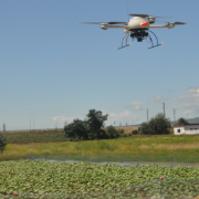
El proyecto se llevó a cabo empleando la técnica de Fotogrametría terrestre y aérea y luego procesando las fotos obtenidas en el software Photoscan para finalmente obtener el modelo 3D. Durante la toma de fotos se han medido coordenadas de puntos de apoyo (GCP) y puntos de control (CP) que luego servían para georreferenciar el modelo y medir error (RMSE). Como el paso final se hizo presentación interactiva con fin de difundir y acercar este patrimonio cultural a muchas más personas por la red de internet.

Multi-temporal imaging using an unmanned aerial vehicle for monitoring a sunflower crop

Francisco Agüera Vega, Fernando Carvajal Ramírez, Mónica Pérez Saiz, Francisco Orgaz Rosúa

2015

Biosystems engineering 132: 19-2 7

http://dx.doi.org/10.1016/j.biosystemseng.2015.01.008

ABSTRACT

The objective of this study is to determine the capability of an unmanned aerial vehicle system carrying a multispectral sensor to acquire multitemporal images during the growing season of a sunflower crop. Measurements were made at different times of the day
and with different resolutions to estimate the normalised difference vegetation index (NDVI) and study its relationship with several indices related to crop status with the aim of generating useful information for application to precision agriculture techniques. NDVI
was calculated from images acquired on four different dates during the cropping season.
On two of these dates, two images were acquired to determine how the time of day when the images were taken influences NDVI value. To study the influence of image resolution on NDVI, the original images were resampled to 30 x 30 and 100 x 100 cm pixel sizes. The
results showed that the linear regressions between NDVI and grain yield, aerial biomass and nitrogen content in the biomass were significant at the 99% confidence level, except during very early growth stages, whereas the time of day when the images were acquired,
the classification process, and image resolution had no effect on the results. The methodology provides information that is related to crop yield from the very early stages of growth and its spatial variability within the crop field to be harvested, which can subsequently
be used to prescribe the most appropriate management strategy on a site-specific basis.

Water balance in artificial on-farm agricultural water reservoirs for the irrigation of intensive greenhouse crops

Fernando Carvajal Ramírez, Francisco Agüera Vega, Julián Sánchez-Hermosilla López.

2014

Agricultural Water Management 131: 146– 155

http://dx.doi.org/10.1016/j.measurement.2016.12.002

ABSTRACT

The intensive-cropping system used in southeastern Spain is one of the most productive of the European Union. It is based on the efficient use of irrigation water using localised irrigation systems with water obtained mostly from small artificial on-farm agricultural water reservoirs (AWRs) that meet the evapotranspiration demands of the intensive greenhouse crops.

Several public and private initiatives have attempted to optimise the distribution of the water from wells and desalinating plants to avoid losses in the delivery network. However, the AWR water loss to evaporation could be dramatically reduced with the use of plastic shade materials. In addition, simple water-collection devices for capturing rainwater from the greenhouse roofs, which are currently used in more than half of the greenhouses of the study zone, recirculate water to the irrigation AWRs, significantly improving the water balance of the system.

The present work provides a monthly balance of the water deficit that could be overcome in an AWR over an irrigation season considering the rainwater directly received by the AWR, the losses due to direct evaporation from the AWR, and the water demand that must be met to provide sufficient irrigation. These water balances were compared with those that would occur if the AWR had been covered with shading material to reduce direct evaporation and if the rainwater from the greenhouse roofs had been collected in the AWR. When applying both of these management approaches, the annual water deficit decreased by 53.02%

Adquisición y análisis de imágenes tomadas desde una aeronave no tripulada para el manejo localizado de cultivos en Agricultura de Precisión

Fecha de defensa:

2013

Doctorando:

Mónica Pérez Saiz

Directores:

Francisco Agüera Vega

Fernando Carvajal Ramírez

Julián Sánchez-Hermosilla López

https://www.educacion.gob.es/teseo/mostrarRef.do?ref=1065159

RESUMEN

 El Manejo Localizado del Cultivo (MLC) se refiere a un sistema agrícola de rápido desarrollo que promueve prácticas de manejo agrícola variables dentro de un campo de acuerdo a las condiciones específicas del lugar. Una información esencial para el MLC es la relacionada con la topografía del cultivo teniendo en cuenta que por un lado están los mismos factores que influyen en la eficiencia: la pendiente, inundado de ciertas áreas, etc., y por otro lado es necesaria la georeferenciación de las tareas a realizar para ser capaz de llevar a cabo el trabajo de los sensores y las máquinas en el lugar correcto. Es por esta razón por la que la primera tarea a realizar en MLC es el levantamiento topográfico del cultivo. Las técnicas utilizadas para dicha labor varían en función de la procedencia de los datos: la medición in situ de las coordenadas con instrumentos clásicos como la estación total o GPS (del inglés Global Positioning System), actualmente no son económicamente viables en MLC. La restitución fotogramétrica de las imágenes aumenta el rendimiento, pero no es factible en MLC debido al coste del software y el hardware necesario, así como el grado de especialización requerido. El uso de satélites de alta resolución e imágenes de aviones tripulados limitan a menudo su uso en MLC. En tales casos, el uso de vehículos aéreos no tripulados (UAV, del inglés Unmanned Aerial Vehicles) puede ser una alternativa práctica a los satélites y los vuelos tripulados aéreos para imágenes de alta resolución. Esta tesis se divide en cinco capítulos diferentes. En el primer capítulo se presenta una revisión general del tema. El segundo está relacionado con la calibración geométrica de la cámara digital no métrica utilizada para la producción de las ortoimágenes y Modelos Digitales de Elevaciones (MDE) de diferentes zonas de estudio. Para este trabajo se probaron diferentes metodologías y la precisión de los resultados muestra que la cámara digital de bajo coste y el software fotogramétrico comercial empleado para la calibración de la cámara se pueden utilizar para la fotogrametría UAV con resultados precisos. En el tercer capítulo se presenta una metodología para producción de ortoimágenes y MDE con fotogrametría UAV y la evaluación de la exactitud de los productos. En este capítulo se obtuvieron ortoimágenes y MDEs utilizando imágenes tomadas con una cámara digital compacta no métrica montada en un UAV. Se utilizó un software fotogramétrico comercial de bajo coste para el procesamiento de las imágenes y se evaluaron las precisiones de los productos obtenidos calculando el Error Medio Cuadrático (EMC). Los resultados muestran que la metodología y el equipo utilizado en este trabajo son adecuados para obtener productos fotogramétricos de precisión y a bajo coste. El siguiente capítulo prueba la capacidad de las imágenes multiespectrales y multitemporales (bandas infrarrojas, rojo, azul), adquiridos a partir del UAV durante el crecimiento de un cultivo de girasol en diferentes momentos del día y con diferentes resoluciones, para estimar el indice de vegetación de diferencia normalizada (NDVI, del inglés Normalized Difference Vegetation Index) y estudiar su relación con varios índices relacionados con el rendimiento de los cultivos, con el objetivo de generar información útil para aplicar las técnicas de Agricultura de Precisión (AP). Los resultados muestran que el UAV utilizado en este trabajo ha demostrado ser una buena plataforma para la utilización de un sensor que permite el cálculo de NDVI de un cultivo de girasol en su desarrollo. Además, las imágenes pueden ser tomadas en los momentos críticos a lo largo del crecimiento del cultivo, sin límites debido a las condiciones climáticas y la disponibilidad del dispositivo. En el último capítulo se presentan las conclusiones generales de la tesis.

Low cost surveying using an unmanned aerial vehicle

Mónica Pérez Saiz, Francisco Agüera Vega, Fernando Carvajal Ramírez

2013

UAV-g 2013. International Archives of the Photogrammetry, Remote Sensing and Spatial Information Sciences – ISPRS Archives 40: 311-315

http://www.scopus.com/inward/record.url?eid=2-s2.0-84896036384&partnerID=MN8TOARS

ABSTRACT

Traditional manned airborne surveys are usually expensive and the resolution of the acquired images is often limited. The main advantage of Unmanned Aerial Vehicle (UAV) system acting as a photogrammetric sensor platform over more traditional manned airborne system is the high flexibility that allows image acquisition from unconventional viewpoints, the low cost in comparison with classical aerial photogrammetry and the high resolution images obtained. Nowadays there is a necessity for surveying small areas and in these cases, it is not economical the use of normal large format aerial or metric cameras to acquire aerial photos, therefore, the use of UAV platforms can be very suitable. Also the large availability of digital cameras has strongly enhanced the capabilities of UAVs. The use of digital non metric cameras together with the UAV could be used for multiple applications such as aerial surveys, GIS, wildfire mapping, stability of landslides, crop monitoring, etc. The aim of this work was to develop a low cost and accurate methodology in the production of orthophotos and Digital Elevation Models (DEM). The study was conducted in the province of Almeria, south of Spain. The photogrammetric flight had an altitude of 50 m over ground, covering an area of 5.000 m2 approximately. The UAV used in this work was the md4-200, which is an electronic battery powered quadrocopter UAV developed by Microdrones GmbH, Germany. It had on-board a Pextax Optio A40 digital non metric camera with 12 Megapixels. It features a 3x optical zoom lens with a focal range covering angles of view equivalent to those of 37-111 mm lens in 35 mm format. The quadrocopter can be programmed to follow a route defined by several waypoints and actions and it has the ability for vertical take off and landing. Proper flight geometry during image acquisition is essential in order to minimize the number of photographs, avoid areas without a good coverage and make the overlaps homogeneous. The flight planning was done using the MdCockpit software, with the module waypoint editor. Flight route file was downloaded into the quadrocopter autonomous chip via cable. A total of twelve vertical images with a longitudinal and transversal overlapping of 60 % and 50 % respectively were taken. The digital camera was previously geometrically calibrated. Field control points covering the whole studied area were defined over the area of interest and their coordinates were measured by a GPS. Natural targets were used as field control points. The close range photogrammetric software Photomodeler Scanner v.7 was used in this work to calibrate the camera and to carry out the photogrammetric process. The software Golden Surfer was used to produce the DEM. The planimetric and the altimetric root mean square error (RMSE) were calculated in order to check the accuracy of the products. The RMSEx was 6 cm, the RMSEy was 4 cm and the RMSEy was 7 cm. Our preliminary results demonstrate the feasibility and accuracy of orthophotos and DEMs obtained from images captured from a quadrocopter using low cost photogrammetric software. A future work can be the comparison of the products obtained following the route used in this study where the images are taken vertically with the products obtained with an orbital route where the number of images will be diminished and the photos will be taken oblique.